Planning to visit one of our Conservation Areas? Plan your trip by downloading the PDF or mobile map you’ll need during your visit and take a look at any upcoming service disruptions.
Please follow all park rules during your visit and remember that amenities, such as washrooms and pavilions, are only open from mid-June to mid-October.
Closures
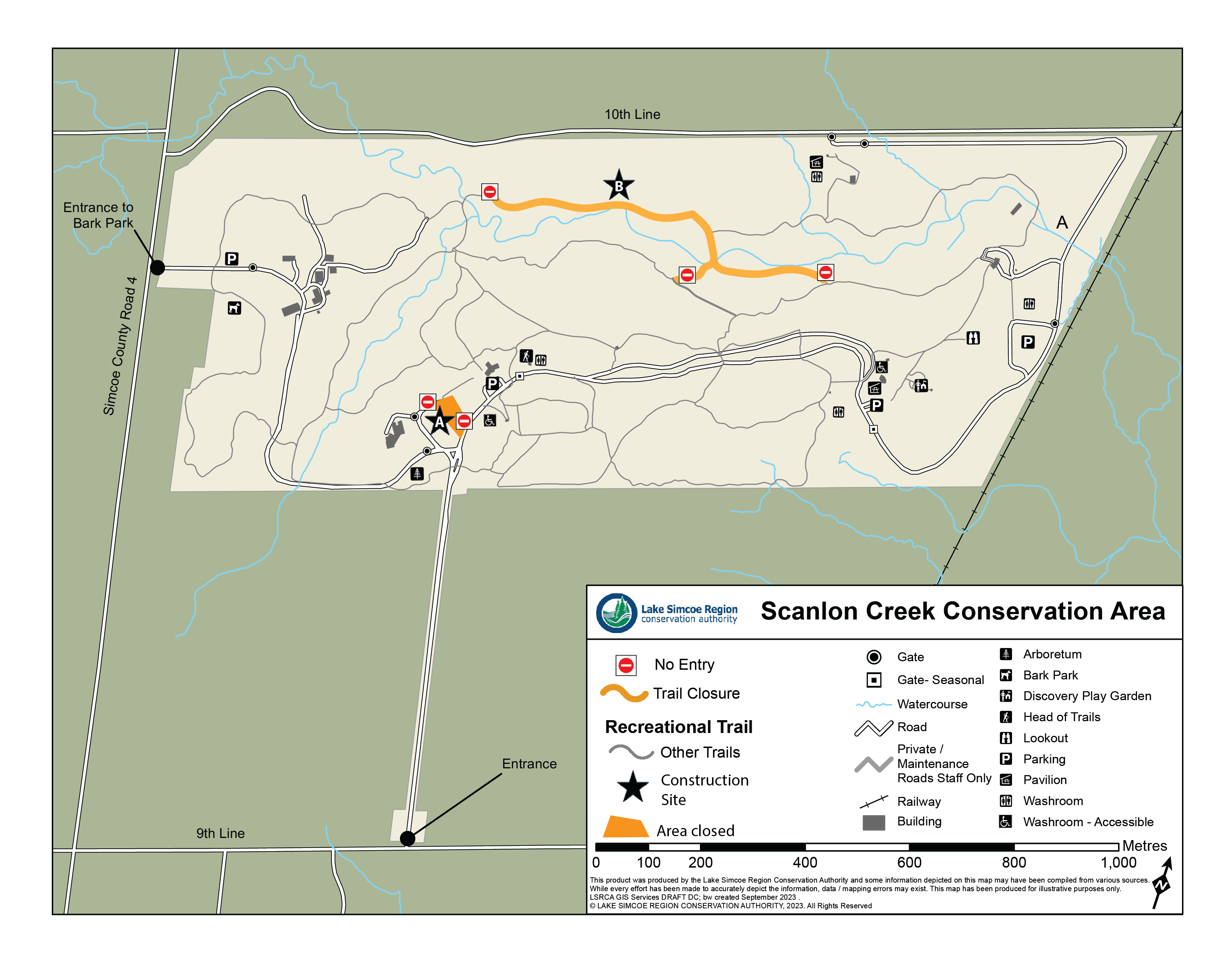
New Nature Centre at Scanlon Creek coming to life!
As part of the initial site preparation phase of this project, tree removals are scheduled from 8 a.m. to 3:30 p.m. between March 18 and March 28, 2024, in the designated area (location A on map). This essential step ensures compliance with regulations protecting breeding birds and wildlife.
We are committed to environmental stewardship and will be offsetting this work through restoration efforts and planting additional trees throughout the Scanlon Creek Conservation Area.
For your safety, please obey all temporary road or trail closure signs, exercise additional caution around all roadways, and stay clear of the work area.
If you have any questions, please contact: Phil Davies at p.davies@lsrca.on.ca
A section of the Kingfisher Trail remains temporarily closed (location B on map).
Simply download the app on your smartphone and use it when you visit. It’s that easy! Once the map is downloaded, you won’t have to use your data when you hit the trails.
How to use Avenza:
Download the Avenza app on your mobile phone.
Open the app (when prompted, consider allowing Avenza to access your location for optimal use).
Create an account (or click the small white X in the top right corner to skip this step).
Tap the Store button on the bottom of the page.
Click on the search bar at the top of the page.
In the location box, choose “Current Location” if you are looking for conservation areas that are closest to you, or change to “Any Location” to see all our available maps.
In the Keywords box type in LSRCA, then click search.
When you find the map you are looking for, tap the “Free” button, then tap again on “Download?” This will add the desired map to your app.
Click on My Maps (bottom left icon), select your map and hit the trails! Once you install your map, you no longer need access to data.
Our maps may change over time! To ensure you have the latest download, join our email list. We’ll send you an email when we release a new version of the map.