The Lake Simcoe Region Conservation Authority

Riverine Flood Status
Normal
Lake Simcoe Shoreline Status
Hazard Watch
Low Water Status
Normal

Lake Simcoe Water Levels

Lake Simcoe Water Levels

Each year questions about Lake Simcoe ​water levels come up: Who controls them? Why are they so low? Why are they so high? The fact is Lake Simcoe water levels are not “controlled”, they are “managed” with the understanding that climate conditions are complex and can be unpredictable at times. Here are some facts that provide a better understanding of Lake Simcoe water levels and how they are managed. 
 
To begin, Lake Simcoe is part of a much larger system known as the Trent-Severn Waterway (TSW). Ultimately water levels in Lake Simcoe are mana​ged by Park​s ​Canada, the Federal Government, via the Trent-Severn Waterway. Management of this system is extremely complex and considers all the varying needs and impacts that each decision or action will have on the rest of the system.

Depending on your relationship with the lake, you may have a different perspective on water levels; however, we do need to remember that Lake Simcoe is only one part of a much larger system. A balance must be achieved between managing water levels to prevent flooding of property and managing water levels for recreational use and fish and wildlife habitats.​

Changes in Lake Simcoe Water Levels

Typically Lake Simcoe water levels vary by about 0.4-0.5 metres during any given year. The highest levels
usually occur between April and June. As the summer progresses, the levels begin to drop because of
increased evaporation and reduced inflows. The lowest levels are reached in late fall and winter.​

Why can’t the water levels in Lake Simcoe stay higher, longer?

Because Lake Simcoe is ​a part of the larger Trent-Severn Waterway system, actions taken to change the water levels in Lake Simcoe cannot occur in isolation of the entire TSW system. That’s because what happens in one lake or river impacts rivers and lakes both upstream and downstream. For example, keeping Lake Simcoe water levels higher into late summer increases the potential of flooding in cottage country the following spring. This is because Lake Simcoe acts as a large storage basin for winter and spring snowfall, melt-water and precipitation. If the lake levels are kept high for too long, essentially there wouldn’t be enough room in the lake to hold the water from these natural cycles, which would cause flooding and other environmental issues within the watershed.
 

Why are Lake Simcoe Water levels lowered in the summer?

The lowering of water levels which occurs every year at the same time is referred to as “drawdown”.
 
Drawdown begins in the summe​r because it takes time to gradually reduce the levels in the lake. This needs to take place to make room for the precipitation that happens in the fall, winter and spring. In order to protect against flooding and optimize public safety throughout the interconnected system, the lake is lowered to make room for high inflows that are typical over the non-navigation (off-boating) seasons.
 
It is important to note that Lake Simcoe water levels do not actually fluctuate all that much (see chart). Historic lows run at 218.4 metres and historic highs run at 219.5 metres. Actual fluctuations over the course of any one year are even smaller.

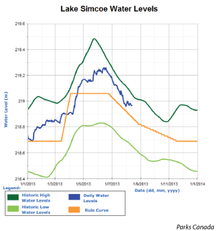
Are there other factors that affect Lake Simcoe water levels?

Yes. Significant and sustained winds can result in increased water levels along windward shorelines. For example, three to four consecutive days of strong westerly winds may cause increased water levels along the eastern shores of Lake Simcoe. Changes in lake water levels caused by significant wind is known as a “seche” or “seching”.

Water levels are important to fish and wildlife

It is essential to have the TSW systems water levels lowered prior to fish spawning as fish spawn close to the water’s edge in shallow areas. If the drawdown is done after eggs have been laid, the eggs may be exposed, dry up and die. This will not only affect fish and their habitat but other ​wildlife as well.​

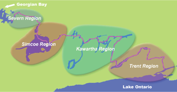
Quick Facts: Trent-Severn Waterway

The Trent-Severn Waterway (TSW) is a National Historic Site which offers a navigable route for recreation and commerce.​ ​It is 386 km long, 18,600 square kilometers of interconnected lakes, rivers and channels connecting Lake Ontario at Trenton to Georgian Bay at Port Severn. Nearly 50 communities are located on its shores. Hundreds of thousands of people rely on this waterway for drinking water, flood control, tourism and recreation. It provides water for power generation, municipal water supplies and agriculture, and supports a tremendous variety of fish and wildlife. The Trent-Severn Waterway is an important economic, environmental and recreational resource used by thousands of boaters, shoreline residents, businesses and vacationers every year.

For more information, please visit Parks Canada​​.​​

Scroll to Top