Lake Simcoe Science
Groundwater Recharge
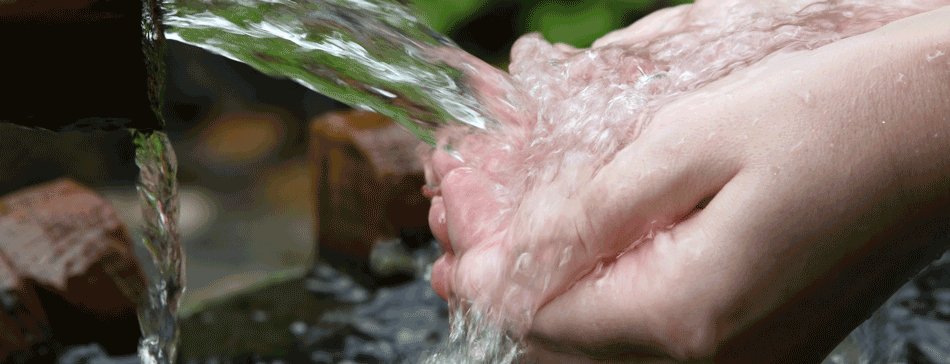
Do you know where your tap water comes from?
If you live in the Lake Simcoe watershed, chances are it comes from underground. Approximately 65 per cent of people within the Lake Simcoe watershed rely, at least in part, on groundwater for their source of drinking water. The same cannot be said for the rest of the province though. In Ontario generally, between 20 and 30 per cent of the population relies on groundwater sources. The remaining 70-80 per cent rely on surface water sources, such as lakes and rivers.
Groundwater is a difficult natural resource to understand because it’s so hard to see and observe. It’s even more difficult to explain. But it plays an important role in our lives… just as important as the sparkling lakes and rivers.
So What Exactly is Groundwater?
It seems a bit contradictory – all that water … in the ground? The fact is the earth is filled with water. Groundwater is found in between the tiny spaces in our soil, silt, sand and rock. It is stored in and moves slowly through geologic formations called aquifers.
Main types of aquifers
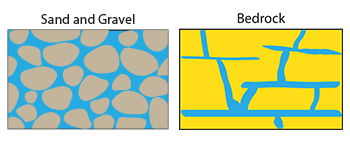
Aquifers are underground layers of sand, silt and gravel or fractured rock saturated with water, from which groundwater can be pumped to the surface.
Where groundwater can be found, it fills the spaces between sand grains, in rock crevices, and in limestone openings.
While the water we take from underground is replaced through natural processes over time, it is possible to take water more quickly than nature can replace it, leading to shortages. By developing a solid understanding of our groundwater resources, we can develop sustainable usage rates to ensure that doesn’t happen.
Why is Groundwater so Important?
Groundwater serves as a primary drinking water source in our watershed and plays an important ecological role. It supports the health and well-being of many natural systems that contribute to a healthy watershed, such as wetlands, rivers and streams.
You might think that rivers and streams get their water from overland flow as a result of precipitation. While this is true, many rivers are supplied – at least in part – with fresh water through underground upwellings in the riverbed. These upwellings are important to the natural cycle as they help prevent watercourses from drying out in the summer. They also keep the water temperature cooler, which supports coldwater fish species such as brook trout. Wetlands too are fed partially through underground water sources.
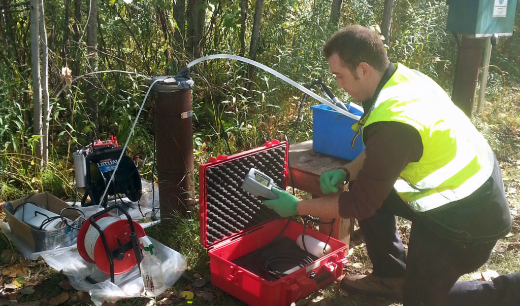
If groundwater is not managed sustainably, we may impact the sources of water that contribute to these natural features. Understanding the source of the water is the first step. LSRCA actively monitors our groundwater resources. We are part of a province-wide network of 36 conservation authorities and 10 municipalities (in areas not covered by a conservation authority) that collects and monitors groundwater information.
Groundwater Recharge Areas
An important component in understanding and protecting groundwater starts with identifying areas of groundwater recharge.
Groundwater recharge areas contain soil that is porous and allows water to infiltrate into the ground. This water refills our aquifers, makes its way to streams and wetlands or provides a source of water from which we can draw upon. When we know the recharge areas, we can better understand groundwater and more importantly, how to protect it. The Oak Ridges and Oro Moraines are examples of groundwater recharge areas. Efforts to protect it are made exactly because of its importance in replenishing underground aquifers.
Oak Ridges Moraine
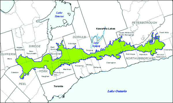
The Oak Ridges Moraine is a major groundwater recharge system and a primary water source for many watercourses within the Lake Simcoe watershed.
Groundwater recharge areas can be divided into two classes:
Significant Groundwater Recharge Areas (SGRAs)
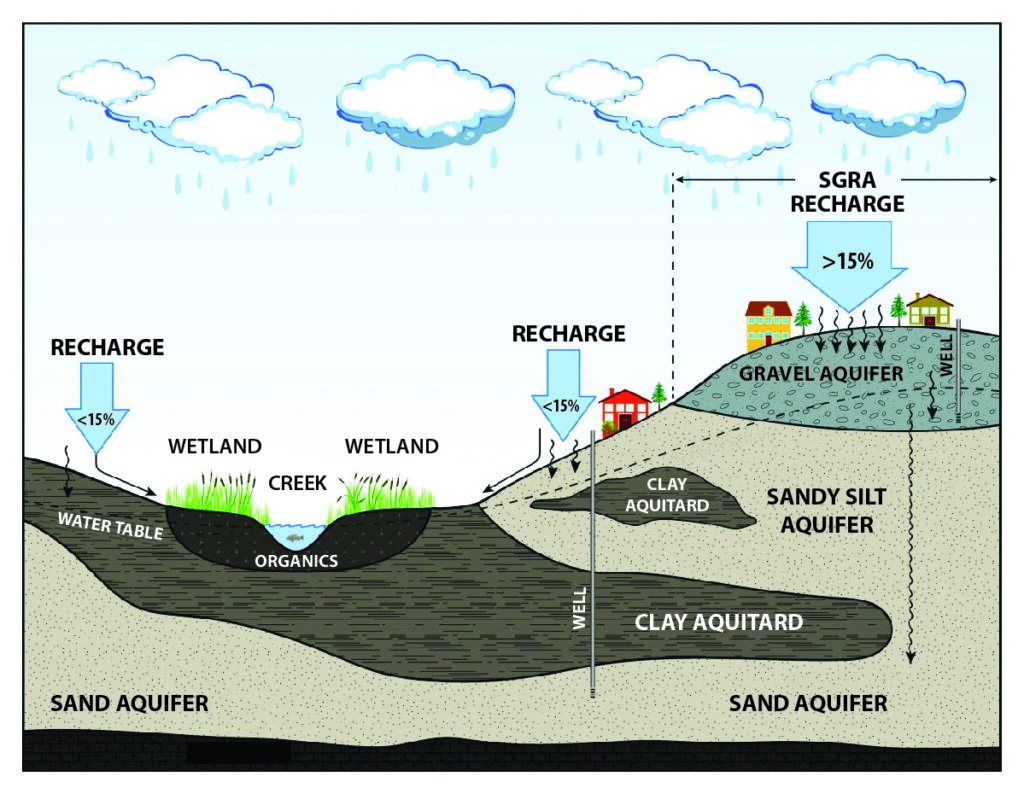
Significant Groundwater Recharge Areas (SGRAs) are surfaces on the landscape that allow a high volume of water to penetrate the surface – higher than the average for the entire watershed. The soil in these areas is typically characterized by permeable, loosely packed, coarse materials such as gravels and sand or fractured bedrock at surface which allow rain and snowmelt to enter the ground easily. In order to find these areas on the landscape, models that calculate recharge are used to estimate the average recharge. If the recharge rate for a particular area is higher than 15% above the average, it’s considered significant.
The diagram depicts areas of the landscape that are considered a Source Water Protection SGRA, where both a drinking water well and an annual average recharge rate greater than 15 per cent of the entire Lake Simcoe watershed recharge rate are present.
Ecologically Significant Groundwater Recharge Areas (ESGRAs)
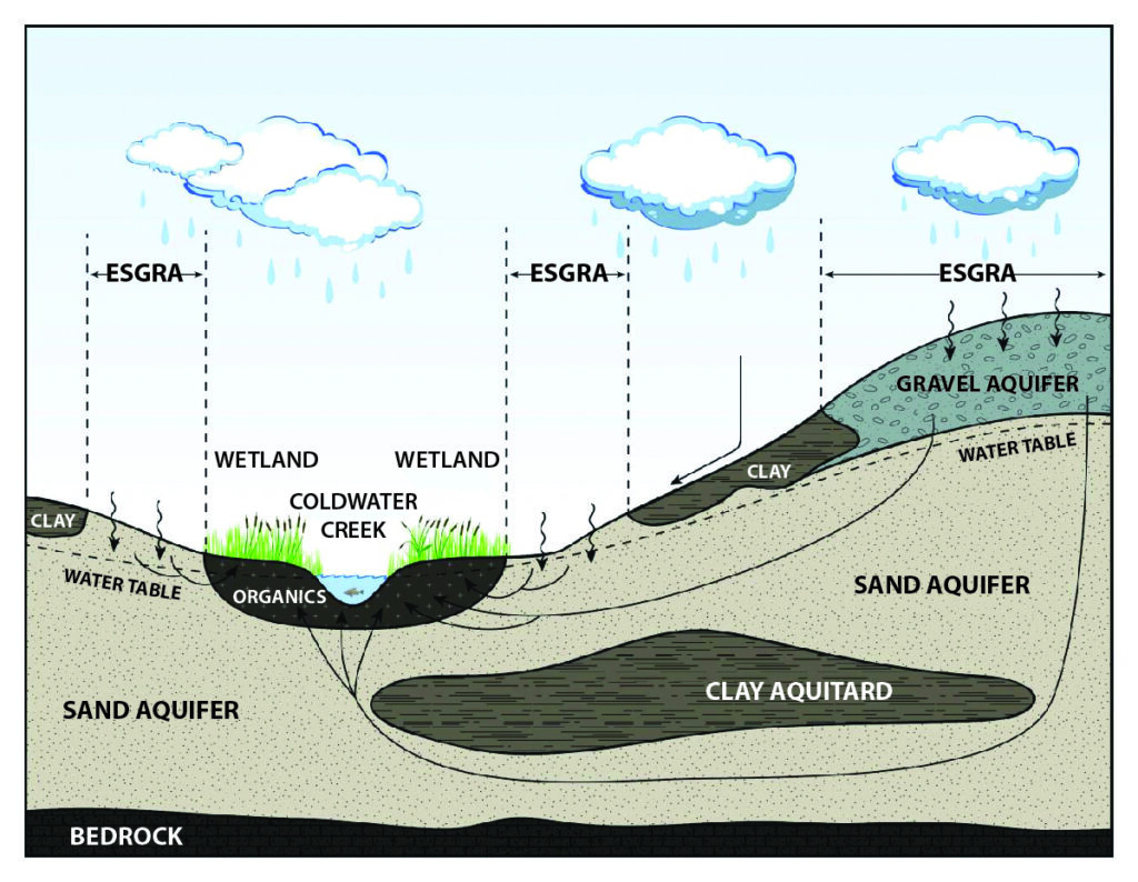
Ecologically Significant Groundwater Recharge Areas (ESGRAs) are areas on the landscape that feed a particularly sensitive ecological feature such as a wetland, river or stream.
SGRAs and ESGRAs are not the same. An area can be classified as being an Ecologically Significant Groundwater Recharge Area that is not necessarily a Significant Groundwater Recharge Area and vice versa. One is more about volume (SGRA) while the other is more about feeding an ecological feature (ESGRA).
This diagram depicts areas of the landscape that are considered to be ESGRAs. To establish the ecological significance of the recharge area, a linkage must be present between the recharge area and the ecologically significant feature (e.g., a reach of a coldwater stream, a wetland, or an area of natural or scientific interest (ANSI)).
The Science of Mapping Groundwater
Understanding how water flows beneath the ground is not a simple task and requires a significant investment in science. We actively employ a Hydrogeologist as part of our groundwater monitoring efforts. Hydrogeologists are the experts who study the movement of water underground.
Mapping underground water requires piecing together information from large numbers of well records to get a picture of the underground environment (water levels, layers of different type of sediment and rock, etc.). This information gives a picture of the different aquifer and aquitard (less permeable materials such as clay & tills) formations beneath the ground and how quickly water flows through them. The information is then fed into computer models that simulate how the water flows beneath the ground.
In the computer simulated models, particles are released from various locations (such as streams, wetlands) and tracked backward through the ground to their origin at the surface. The location where the particles end up on the surface is classified as Ecologically Significant Groundwater Recharge Areas (ESGRAs).
The mapping of ESGRAs differs greatly from how we map Significant Groundwater Recharge Areas (SGRAs). SGRAs are also mapped with a computer-based model, but instead of simulating what is happening beneath the ground, these are surface water models that focus on what happens to water on the surface. They use surficial (surface) geology, land use and climate data to determine the amount of snow and rain water that penetrates the ground versus running overland to water courses and the lake.
Groundwater Model Layers for the Oro Moraine
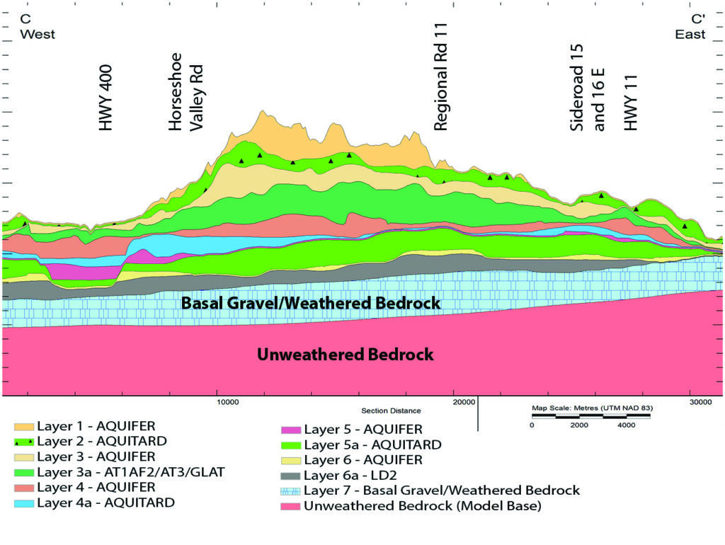
Layers of aquifers (e.g. sands and gravels) and aquitards (e.g. clay, tills) conceptualized in a groundwater model for the Oro North, Oro South and Hawkestone Creeks subwatersheds. Image: Earthfx, 2013.
What is LSRCA Doing to Protect Groundwater?
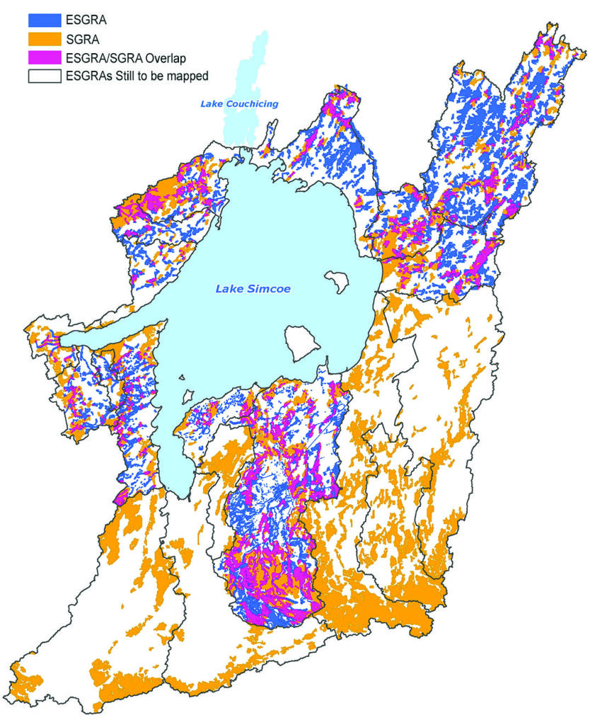
Knowing where these areas are is the first step to protecting them. LSRCA has mapped all the Significant Groundwater Recharge Areas in the watershed and is working towards completing the Ecologically Significant Groundwater Recharge Area mapping. These maps have been produced through funding provided from the Province of Ontario in support of the Lake Simcoe Protection Plan and Clean Water Act.
With the knowledge provided from this work, we are in a position to work with municipalities and developers to put measures in place that will help mimic a site’s natural recharge patterns so that development doesn’t impact the recharge volume.
For example, if a site is to be developed, one of the strategies we are employing is to encourage “Low Impact Development” so where development does take place, as much of the water as possible is managed on site, allowing the natural water cycle to be disrupted as little as possible.
We also work with municipalities and agencies to provide training around practices that have the potential to contaminate our underground water supplies, such as Smart About Salt®.
Ontario’s Source Water Protection program has helped us understand where our local water supplies are so that activities having the potential to contaminate or reduce the quantity of drinking water sources can be avoided.
What You Can Do
We are very lucky in Ontario to have abundant, clean water. However, factors such as climate change, a growing population and inefficient (wasteful) use will lead us down the path to water restrictions and even shortages. We can thus benefit from improved water conservation, if not for ourselves, then for our children.
If you rely on groundwater as your source of drinking water, have your well inspected and maintained regularly by a licensed well contractor. Like any piece of equipment, a well has a lifespan and requires preventative maintenance in order to ensure its effective and safe supply of water.
What about your waste? Are you on municipal services or do you have a septic system? Septic systems require regular maintenance to operate efficiently. Because it’s underground, a poorly functioning septic system, can contaminate groundwater sources.
Do what you can to direct clean water into the ground and away from paved surfaces on your property. Some simple things you can do include installing a rain barrel, building a rain garden or directing downspouts away from driveways and onto grassed areas.
Take advantage of your municipal services such as Hazardous Waste Depots for your old or unused chemicals. Please don’t pour this kind of product down your drain. It ends up in the water supply eventually. You can often bring expired or unused medications back to your pharmacy and they’ll ensure proper disposal.
Share what you’ve learned with others. Word of mouth is a powerful tool; we rely on our current supporters to help find new supporters.
Who to Contact:
Customer Service
Phone: 905-895-1281
Toll Free: 1-800-465-0437
Email: info@LSRCA.on.ca
This newsletter was published in Lake Simcoe Living Magazine in 2015.