Flood Forecasting
Our critical role in flood protection
Flooding is the most dangerous natural hazard in Ontario in terms of property damage, civil disruption and even death. Flooding is also the leading cause of public emergency, now even surpassing fire as the number one cause of household insurance claims in Ontario.
The aftermath of severe flooding hit home when Hurricane Hazel pounded its way through southern Ontario on October 15, 1954, bringing heavy rains and ensuing flooding unlike anything ever before. Its devastation was a wake-up call of the most tragic kind; 81 lives were lost and 4,000 people were left without homes.
In its wake, conservation authorities were given extra responsibility for managing the risks associated with flooding. As a result, flood protection and prevention is now one of LSRCA’s central mandates.
How we shore up against flooding
We apply a proactive, multi-tiered approach in our efforts to reduce or eliminate the impacts of flooding. Through science and regulation, we protect by knowing where the flood prone areas are and keeping development away or mitigating its effects. We also employ staff who track data daily to stay alert to the potential for flooding so we can warn the appropriate authorities.
Our flood protection methods include:
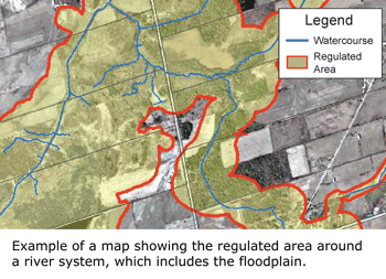
- Maintaining an extensive library of maps which illustrate natural and man-made features of the watershed, so we know which areas are more prone to flooding.These topographic maps are created using field work and computer modelling. Computer models are used to calculate water flows and water levels during storms based on various scenarios. In this part of Ontario, we map the Hurricane Hazel flood event to protect that area from development.The water level information gathered is then applied to a map of the river system, showing the areas where floods are more likely to occur.
- Managing development in flood prone areas.Have you or someone you know ever been told you need a permit from the conservation authority? It’s probably because the intended activity/development had the potential to either be a negative impact on the environment (if it’s not done correctly for instance) or it could contribute to problems of flooding (either for you or your neighbours).
We understand people sometimes have a hard time relating the impact of their individual project to the greater watershed, but there is no such thing as only one project. Every year, we receive hundreds of permit applications. Our review is required to ensure the work is being done with the watershed in mind. Taken in isolation, it may appear that any one particular permit project has limited impact, but collectively, all these permits add up to the potential for huge impacts on the landscape. - Operating a flood monitoring and warning program to alert agencies in the event we think flooding may occur. As one of 36 conservation authorities in Ontario, we play a key role in flood protection through our monitoring of watershed conditions year round. This includes tracking indicators like water levels in our streams and rivers, how wet the ground already is (known as “antecedent conditions”), measuring snow cover, temperature, expected rainfall/snow accumulation, etc. Our specially trained staff monitor and track these watershed conditions daily. They use all this information to review, compare and provide as precise as possible an analysis of when conditions present themselves for the possibility of a flood. If we think there’s the potential for a flood, we issue a bulletin to local agencies, such as emergency responders, municipalities and school boards.
Local Flood Messages
Flood messages are issued based on three types of messages.
There are 3 types of local flood messages: (1) Watershed Conditions Statements: Water Safety – high flows, unsafe banks, melting ice or other factors could be dangerous for recreational users; Flood Outlook – early notice of the potential for flooding. (2) Flood Watch – flooding is possible in the near future. (3) Flood Warning – flooding is imminent or already occurring.
Keeping you and your family safe
- Every household should have a 72 hour emergency kit. Check with your local municipality about what to include or visit getprepared.gc.ca for an emergency preparedness guide.
- In the event a flood bulletin is issued in your area, stay well away from streams and rivers. Water levels can rise with very little notice, making them dangerous places.
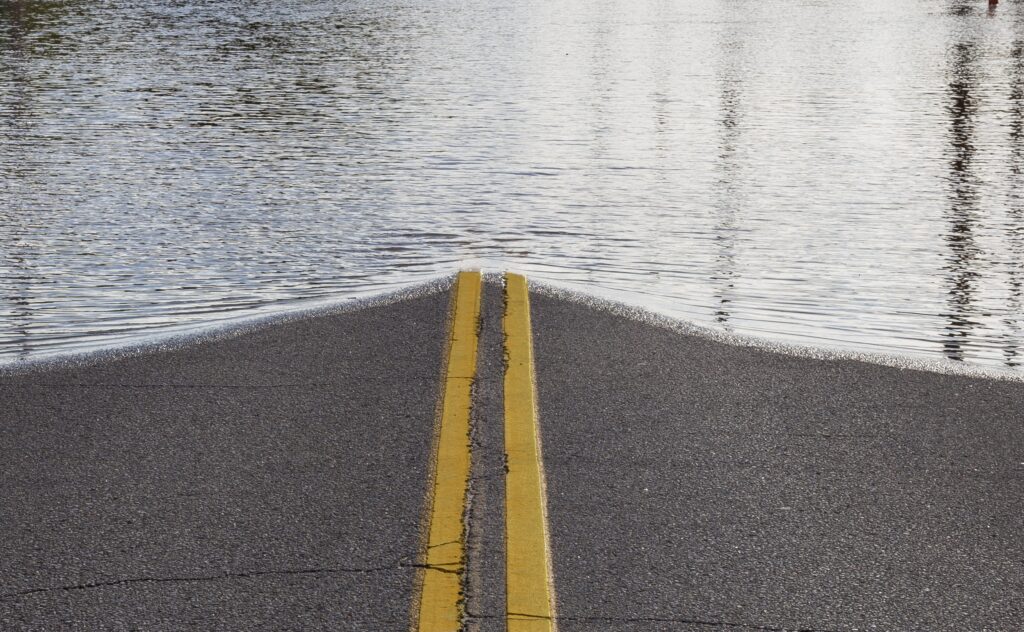
- Most flood-related deaths occur in cars. If you’re driving and you come across an area that has been flooded, do not drive through. You can’t be sure of the depth of the water or the condition of the road beneath it, which may be broken up or washed away.
Flood protection is a shared role
- Support our flood protection efforts. Ask the provincial government to provide more funding support to conservation authorities so we can maintain updated floodplain mapping.
- Build responsibly. When you’re doing work on the landscape, make sure you’re getting the appropriate permits. Remember, your project is only one of many – every small change on the landscape can add up to big impacts.
Who to Contact:
Customer Service
Phone: 905-895-1281
Toll Free: 1-800-465-0437
Email: info@LSRCA.on.ca
This newsletter was originally published in 2017 in Lake Simcoe Living Magazine.